Beyond Tiki, Bilge, and Test / Beyond Tiki
Whats that white stuff on the ground?
Pages: 1 4 replies
|
T

tikijackalope
Posted
posted
on
Tue, Jan 17, 2006 10:02 PM
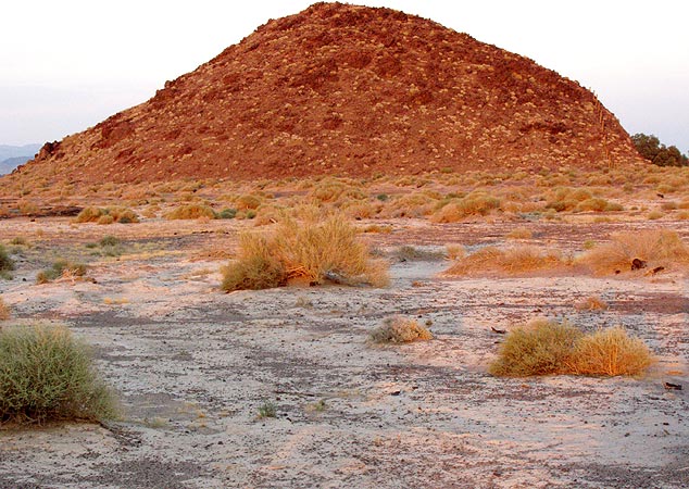
Hey California people, I'm writing about Rt66 in the Mojave Desert and am wondering about this white crust I saw on the ground, particularly from about Newberry Springs to Daggett. I know this is in the region of Bristol Dry Lake so I think it might be salt (I should have tasted it) but I also know borax and various phosphates are found in this region. Amboy, not too far to the east in geological terms, even had a phosphate plant. What is this dirty white crust? (A question I hope nobody ever has to ask a dermatologist) |
|
G

Gigantalope
Posted
posted
on
Wed, Jan 18, 2006 6:49 AM
I know that area well, I think it's salts, deposits from standing water, and gypsum. There are some cool mines out that way that you can still tour, along RT 666. (Avoid Roy's at Amboy...cool looking but it sucks) There are several stories of there once being an inland sea stretching from that area down to Mexico. Not like a billion years ago, but in the time of human habitation. (it's one of those things native americans chat about at the swap meet) Whilst you are there, drive thru the remote parts of Joshua Tree Park. It's locate where two vastly different types of deserted (Colorado and Mojave) meet. There are some high points where it's fun to look down and see the San Andreas Fault like a spine down the Coachella Valley, or note routes to moraines by the big peaks, where gems are most likely to be. Also...take a few minutes while passing thru Yucca Valley and go north to Pioneer Town. (It's only about 4 miles) The place is truly bizarre. "Counting Crows" are around there quite alot. People are always saying they see the ghost of Gram Parker (I think that's the rockabilly guy) around Pappy and Harriet's Palace. There is also a Tiki Coffee shop(Spunky Monkey it's called to my horror)in Morongo...it's kind of cheesey, but better than starbucks. |
|
T
tikijackalope
Posted
posted
on
Thu, Jan 19, 2006 9:10 PM
Gigantalope wrote:
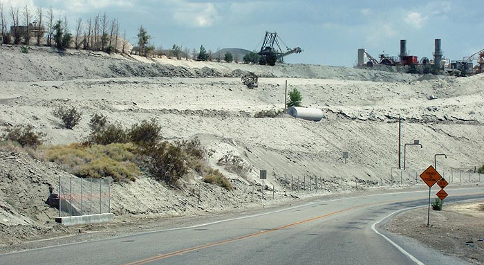
Probably...and that pile in the background of the photo in my first post could be mine tailings. I did notice lots of what looks like gypsum around the north end of Victorville on Rt66 (below)...didn't know if it was natural or overspill from a concrete plant.
Funny you'd mention Roy's; I just got through blogging it. http://thelope.blogspot.com/2006/01/amboy-california.html
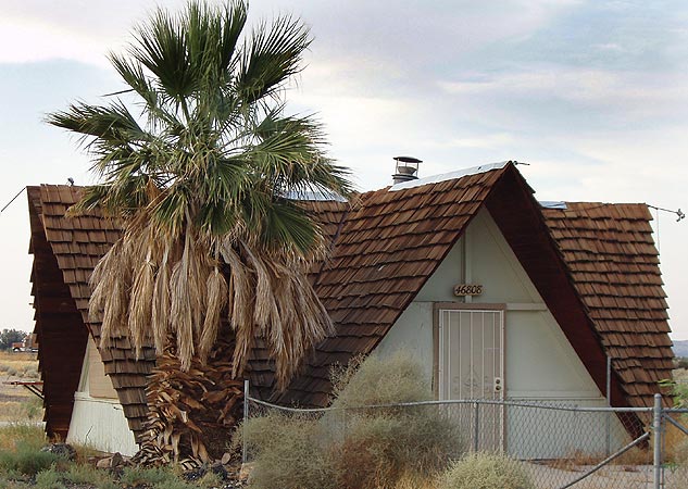
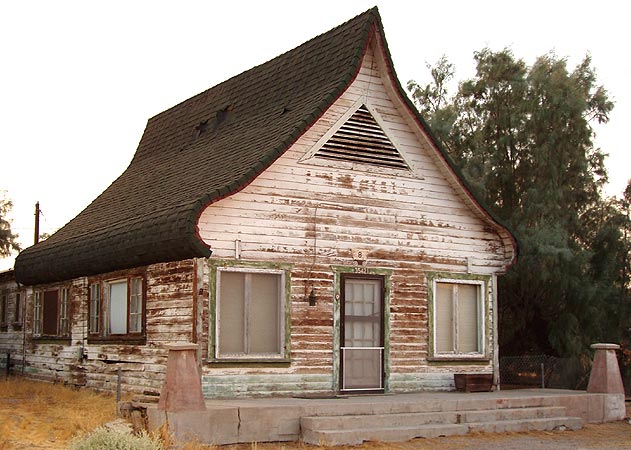
The American heritage Dictionary defines the Mojave Desert as: "An arid region of southern California southeast of the Sierra Nevada. Once part of an ancient inland sea, the desert was formed by volcanic action and by materials deposited by the Colorado River." Since you know the area, any idea what this structure is? This is a mystery building in Daggot; it looks Alpine - the roof seems as if its designed to shed large amounts of snow and ice. I've read it used to be a cafe years ago. Neither it nor the previous structure seem logical in color or form to avoid Absorption of heat, although thats one huge attic vent. Thanks for your other travel pointers, if I get back out that way, I may be in less of a hurry to make a beeline to LA. http://www.thelope.blogspot.com [ Edited by: tikijackalope 2006-01-19 21:11 ] |
|
D

DawnTiki
Posted
posted
on
Fri, Jan 20, 2006 12:25 AM
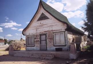
In regards to the onion dome-ish house... Daggett beloved landmark on the southwest corner of Main Street is a quaint and unique structure that was once a cafe from the 1930s. It served travelers on the Mother Road for many years and is still a traffic stopper today. With its delightful curved-roof design and steep roof it reminds me of a Russian home built for the snow country; strangely out of place in the Mojave Desert. Another site refers to the russian pilots (I've heard about) stationed there for training in the 30's.... also served as a secluded airfield for Russian pilots to train from before flying the new aircraft to Nome, Siberia and the Eastern Front. The Russian pilots arrived in Daggett mostly by train; in those days, the Santa Fe and Southern Pacific railroads offered frequent passenger service to Barstow. The pilots were housed at Daggett; they learned to fly the aircraft there and then flew the planes back to Russia. The battle history of these aircraft is essentially unknown. As Rene Francillon says in his book "McDonnell Douglas Aircraft since 1920," "Even though the Soviet Air Force received more aircraft of the ... series than any other Service ... little is known about the operational career of these aircraft." http://www.findarticles.com/p/articles/mi_qa3897/is_200404/ai_n9383204 |
|
M

mbonga
Posted
posted
on
Fri, Jan 20, 2006 6:31 AM
I love those Amboy photos! I was out there by myself in 1985 to hike out to the crater because my family once went on a desert trip through there when I was a kid and I wanted so much to hike out there but there wasn't time. I never forgot that crater and wanting to hike to it so I finally got out there as an adult to see it close up. I ate at that flat-roofed Cafe' since it was the only thing open in town on the weekend, and I wanted to get info on hiking out there in case there was anything I needed to know about. The restaurant employees were reasonably familiar with the crater, though they didn't live in Amboy. My hike didn't go well. I didn't bring any water with me and I was wearing contact lenses and didn't take note of my car location relative to landmarks, and it was a hot day. Soon my eyes became so dry that my contact lenses started falling out, and my throat got so dry that I was rasping when I breathed, and I couldn't find my way back to my car, though the highway was easy enough to find. I walked back to Amboy via the highway, and asked a Mexican guy living alone in one of those tiny houses you photographed if I could have some water to drink. He didn't speak English and thought I wanted a beer, so he gave me a beer. I ended up sticking my head under his sink faucet to get some water, and I paid him for the beer. Interesting trip, and one that made me much more aware of the dangers of desert hiking, and how fast a person can dehydrate out there. I took lots of pics myself and the crater itself was pretty scenic and fun. I wasn't into Googie then as I am now, but that peaked cafe' is definitely pure Googie. I'd love to get out there again and take pics myself. (You didn't get any closeups of the newspaper article in the window, did you?) I'm only guessing, but that 4-peaked tiny structure looks like a real estate sales office. I've seen such mystery buildings with exotic architectures in other places like Florida, too. Anyway, thanks for the pics and memories! |
Pages: 1 4 replies