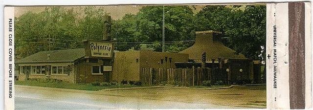
Tiki Central / General Tiki / The Polynesia Waupaca Wisconsin
Post #390926 by The Gnomon on Tue, Jul 1, 2008 1:49 PM
|
TG

The Gnomon
Posted
posted
on
Tue, Jul 1, 2008 1:49 PM
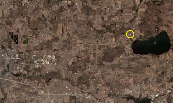
Here is a Google Earth view of the area to the East of Waupaca. The circle in yellow is where the Polynesia used to stand as far as I can tell. It seems to have been leveled.
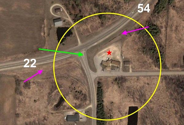
Here is a closer view of the immediate area of the site that I suspect was the Polynesia.
The pink arrows point to what I suspect was the original road as shown on the matchbook (right up next to where the building was). You can see the line, which is similar to lines where roads used to be. It seems like they widened the road and moved it a few yards north. The green arrow represents the direction I believe the picture was taken on the matchbook.
The head of the green arrow is located at the point where I believe Hwy 22 turned into Hwy 54, now both overlapping. If you look at Google Earth from higher up, it lists the road to the right as 54 and the road to the left as 22, but if you drill down it's called 22-54. This is one of the main reasons I believe this is the former site. The other reason is that all the other property is just farmland and there do not seem to be any other locations that could claim to be situated at Hwys 22 & 54, whereas this one is clearly there. From a virtual altitude of about 1500 feet, I cruised both ways along that highway looking for standing buildings or ruins that might have been the Polynesia. I went much farther in each direction than anyone way back when would expect to go to find a place at Hwys 22 & 54, finding nothing. This is the only legitimate spot and it fits. The red star represents where I believe the buildings shown on the matchbook must have been located. The part of the road that you see on the matchbook photo I'm guessing, therefore, is Hwy 54 just east of where it met 22. The buildings you see in the aerial view would have to be located to the right and behind the Polynesia in the matchbook photo. You can see a change in color between the ground where the buildings sit and the ground of vacant lot where I've placed the red star. Because the existing buildings follow that line between the two lots so exactly, I'm guessing that they were built before the Polynesia came down. Maybe having the same owner (being built so close to the line). I would presume that if someone were to drive out to this property and inquire, they'd be able to tell you all sorts of stuff about the Polynesia and who to contact to possibly acquire memorabilia. I assume that's your ad on Craigslist. Good luck. Let me know if my guesses turn out to be correct. Once again too impatient to run spellcheck [ Edited by: The Gnomon 2008-07-01 13:55 ] |