TS

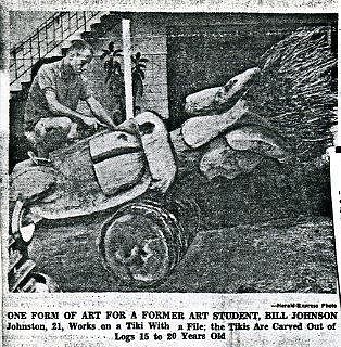
Tom Slick
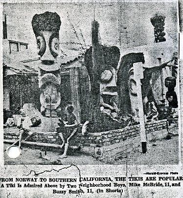
Tiki Socialite
The Beaches of South Bay, SoCal
Joined: Aug 26, 2005
Posts: 1093
|
TS
Actually, I believe it is the 300 block of 38th Pl.
That is based on the direction of the major powerline grid, and specifically the unique staircase railing design with garages below as seen in the vintage picture.
I'd also guess that, what google shows as El Porto Surfboards(now a Liquor store), was actually the workshop, and that is where the tiki is on top of the roof in the old pic. The now current parking lot was most likely where a small bungalow once stood, but was leveled sometime after to make a parking lot for the business building(El Porto Surfboards/Liquor store). It was probably done years before El Porto Surfboards or liquor store was even a thought.
Check the arial photo in google below;
http://maps.google.com/maps?f=q&source=s_q&hl=en&geocode=&q=300+38th+Place,+Manhattan+Beach,+CA&sll=33.901971,-118.418006&sspn=0.000404,0.000736&gl=us&ie=UTF8&hq=&hnear=300+38th+Pl,+Manhattan+Beach,+Los+Angeles,+California+90266&ll=33.901937,-118.418169&spn=0.0004,0.000736&t=h&z=20
and look at the street view;
http://maps.google.com/maps?f=q&source=s_q&hl=en&geocode=&q=300+38th+Place,+Manhattan+Beach,+CA&sll=33.901971,-118.418006&sspn=0.000404,0.000736&gl=us&ie=UTF8&hq=&hnear=300+38th+Pl,+Manhattan+Beach,+Los+Angeles,+California+90266&ll=33.901971,-118.418006&spn=0,0.000736&t=h&z=20&layer=c&cbll=33.901971,-118.418006&panoid=7mP13ovr3NozUnpXkT2LDA&cbp=12,291.11,,0,-4.31
compare it to
For me, the powerlines and stair railings sealed the deal for me, as I thought the article said 36th Pl. too.
If you scan East up 38th Pl., you'll see the major powerlines as seen here;
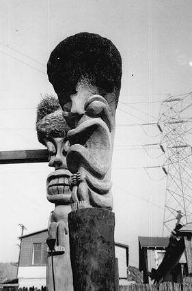
And this photo shows the roof tiki,
which by today would be located up top the liquor store/El Porto Surfboards location. Obviously the bungalow in the vintage photo is now gone, along with the corner brick wall and is now a paved lot.
[ Edited by: Tom Slick 2010-11-16 00:18 ]
|