Pages: 1 5 replies
|
A

AceExplorer
Posted
posted
on
Wed, Jul 18, 2018 9:32 AM
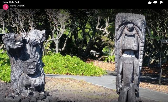
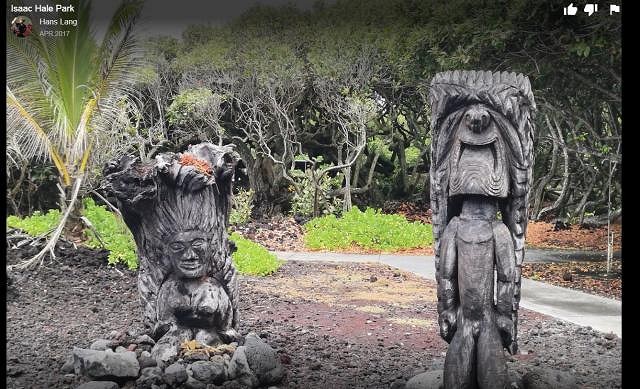
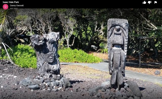
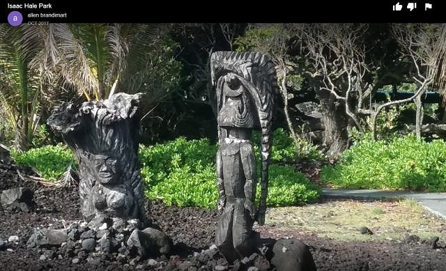
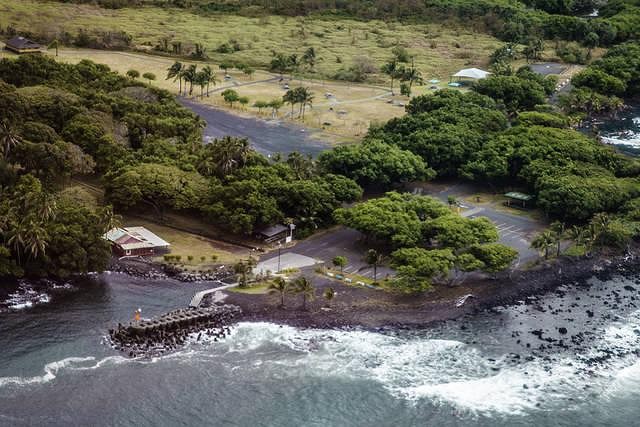
Name:Isaac Hale Park - Big Island of Hawai`i Description: THERE ARE AT LEAST TWO CARVINGS HERE - PHOTOS POSTED BELOW. THIS PLACE IS CURRENTLY IN DANGER FROM APPROACHING LAVA - A TOTAL LOSS OF THE SITE AND THE CARVINGS IS POSSIBLE. |
|
A
AceExplorer
Posted
posted
on
Wed, Jul 18, 2018 9:35 AM
Here are photos of the carvings which are in danger. I screen-snapped these to preserve the names of the persons who posted each of the photos.
|
|
A
AceExplorer
Posted
posted
on
Wed, Jul 18, 2018 9:50 AM
Before I created this topic for Isaac Hale Park (primarily to call attention to the potential loss of the carvings contained therein) I did several searches to avoid duplicating a thread. I only found one single result for Isaac Hale Park, and it was when Wendy ("danlovestikis") posted photos in 2017 of her visit to the park. As of this morning, lava is reported only 750 meters (820 yards) from the boat ramp lagoon. The lava entry point to the ocean has been moving steadily to the west (in the direction of the park) since the eruption started in May 2018. It is possible that this park could be lost in the next few days. The park is currently closed due to the proximity of the lava flow and also the lava haze plume ("laze") which is directly over the park. http://www.hawaiitribune-herald.com/2018/07/18/hawaii-news/lava-oozes-closer-to-pohoiki-isaac-hale/ Hawaii News
Lava from Kilauea volcano’s lower East Rift Zone continues to inch its way along the lower Puna coastline toward Isaac Hale Beach Park and Pohoiki boat ramp. “The ocean entry has expanded to the west, about 750 meters (820 yards) from the boat ramp. The laze plume is directly over the boat ramp,” said Janet Snyder, spokeswoman for Mayor Harry Kim, on Tuesday. The county beach park and state-run boat ramp are adjacent to each other. Stephen Schmelz, Hawaii Island branch manager for the state Department of Land and Natural Resources Division of Boating and Ocean Recreation, estimated the lava, if it maintains its current course and speed, could overtake Pohoiki and Issac Hale park within the next few days. “It would be a significant loss for the people of lower Puna and the Pahoa areas, as Pohoiki is not only popular as a launch ramp for small boats, it is used by a variety of ocean recreational users,” Schmelz said. DOBOR officials had preliminary discussions about new ramp options should the flow overtake Pohoiki. Any plans would hinge on road access being restored and available funding. “We are extremely mindful of the importance of Pohoiki for local people and, as with everything related to Kilauea’s current eruption, we need to be patient and see what develops in the future,” Schmelz said. Concerned citizens posting on social media indicated that turtles are trapped in the Pohoiki area. On Tuesday and during an earlier flight by the Hawaii Fire Department, no turtles were seen. Joining the aerial assessment of the East Rift Zone on Tuesday was Steve Bergfeld, Hawaii Island branch manager for the DLNR Division of Forestry and Wildlife. Bergfeld reported little has changed in Malama Ki Forest Reserve, just to the south of Pohoiki, since his previous assessment of that area. About half of the reserve burned when lava inundated it in the early weeks of the current eruptive event, which began May 3. No new land has recently been lost, but trees in the reserve have been defoliated. “Much of the vegetation is defoliated and stressed from the eruption. We are hopeful that the flora and fauna will recover because they have evolved over time with volcanic activity,” Bergfeld said. According to Snyder, the county’s Highways Division placed a steel plate over a crack in the Volcano Golf and Country Club road and a sign to let drivers know the crack is there. She said Kim “asked people to be aware of unusual things like cracks in the road (and) utility poles that are a little tilted, just because he wants people to be aware of conditions, with all these quakes that are taking place in Volcano.” Fissure 8 continued to erupt lava into the perched channel leading northeastward from the vent. Despite no visible surface connection to the fissure 8 channel, lava continued to ooze out at several points on the 3.7-mile-wide flow front into the ocean. Explosions were reported from the main ocean entry Tuesday morning, with at least one being quite strong. According to the National Weather Service, a weak area of low-pressure tropical disturbance was about 650 miles southeast of Hilo as of Tuesday. NWS said there is a 20 percent chance it will become a tropical cyclone. The front is moving westward between 10 and 15 mph and is expected to pass about 350 miles south of the Big Island, but showers and increased winds are forecast to occur starting today. Heavy rains and high wind gusts of up to 25 mph are expected in the Puna area. This could cause various issues at the shelters, including evacuee tents and tarps being damaged or destroyed. Last Saturday, heavy rains caused the Pahoa evacuation shelter to be inundated to the point that shelter roads were flooded and inaccessible. Similar effects could occur today. Snyder said county Civil Defense Administrator Talmadge Magno said those who remained in Leilani Estates should anticipate dead albizia trees falling if winds increase significantly. The Disaster Recovery Center remains open seven days a week at Keaau High School gym. Hours are 8 a.m.-6 p.m. on weekdays and 8 a.m.-4 p.m. on weekends. As of Monday, the Federal Emergency Management Agency had registered 2,240 people seeking disaster relief and approved $3,909,643 in funding. A community meeting is scheduled for 6 p.m. Thursday at Pahala Community Center to discuss the effects of explosive events and emissions from Halema‘uma‘u crater in Hawaii Volcanoes National Park. The U.S. Geological Survey will provide a presentation. Staff from Civil Defense, the state Highways Division and the county Department of Public Works will be on hand as well to discuss roads and evacuation routes. The issues of sheltering and personal preparedness also are on the agenda. Email John Burnett at [email protected]. |
|
A
AceExplorer
Posted
posted
on
Tue, Jul 24, 2018 2:12 PM
Lava is now 175 to 200 yards from Isaac Hale Park and the carvings - that's a lot of spreading of lava over the past 6 days. When the park was closed due to the gases and lava hazards, I wonder if anyone was able to save the carvings. It's very odd to me that the lava may permanently engulf and encapsulate the concrete boat docks, iron barbeques, restroom sinks and toilets, drinking fountains, and all sorts of other stuff you find in a typical city park. From the US Geological Survey maps this looks like it could be a larger lava flow than the 1860 eruption. Excerpt from today's West Hawaii Today web site: Lava within 200 yards of Isaac Hale Beach Park and Pohoiki boat ramp HILO — Lava had moved to within 200 yards of Isaac Hale Beach Park and Pohoiki boat ramp — less than two football fields in distance — as of Tuesday morning’s overflight by Hawaiian Volcano Observatory. “‘Shacks’ and ‘Bowls’ are gone,” said Janet Snyder, Mayor Harry Kim’s spokeswoman, referring to a couple of popular surf spots near Pohoiki. “We had a 10 p.m. image of Pohoiki area and it showed a bay, this beautiful black sand beach,” Snyder said. “Well, in the eight hours since that time, it’s been filled in with lava. … Pohoiki’s not gone but it’s very close. It’s about 175 meters from the boat ramp.” |
|
J

JasonMa
Posted
posted
on
Wed, Jul 25, 2018 7:15 AM
I don't think so. I've been following the eruption through a Facebook group and shortly before that area became a no-go zone somebody was mentioning the carvings were still there and asking if anyone could take a boat in to save them (since land access was already cut off). Shortly after that even boat access was restricted. |
|
A
AceExplorer
Posted
posted
on
Tue, Aug 7, 2018 8:12 AM
Brief update on Isaac Hale Park, the lava, and the carvings contained therein. The lava has slowed considerably thereby leaving the core of the park somewhere between 200' to 500' from lava. For the time being it seems that the carvings, parking lot, and boat ramp remain intact although still threatened. Lava has covered some parts of Isaac Hale park. It's not unusual for eruptions to slow and then re-start. It's been a nail-biter and will continue to keep us in suspense for a while longer. The park and surrounding areaa are closed due to a number of hazards. Daily overflights and photos from a couple agencies are keeping an eye on the western-most lobe of the flow, the park and boat ramp, and the new delta which is being extended further out into the ocean. |
Pages: 1 5 replies